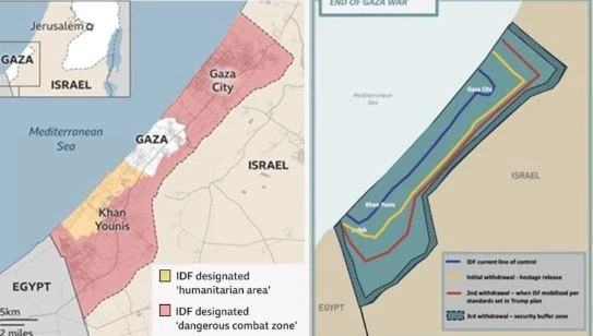
The White House on Monday released a map illustrating the various stages of Israeli troop withdrawal if Donald Trump’s peace plan for Gaza were to be implemented.
Although the map appears somewhat imprecise—for example, Gaza’s southern border with Egypt is not as straight as it is depicted—it provides a general idea of what this peace plan would mean for Palestinian territory.
If implemented according to the boundaries shown on the White House map, the initial military withdrawal would leave about 55% of Gaza under occupation.
The second stage would reduce that figure to around 40% under occupation.
And the final phase of withdrawal, which would establish a so-called “neutral security zone,” would still leave about 15% of Gaza occupied by the Israeli Defense Forces (IDF), according to the BBC.
The peace plan specifies that the “security perimeter presence” would remain in place until Gaza is “sufficiently secured from the resurgence of any terrorist threat.”
The map also shows the current “control line” of the IDF. However, this depiction does not align with analyses of evacuation order zones or designated militarized areas.
The most recent version of the IDF’s own map designates approximately 80% of Gaza as a “dangerous combat zone”, in addition to identifying a section of southern Gaza as a “humanitarian zone.”